Aeronautical information service
АВИАЦИОННЫЙ АНГЛИЙСКИЙ ЯЗЫК
Собранные здесь и снабженные словарем тексты представляют интерес для углубленного изучения профессионального языка, который может оказаться очень полезным при возникновении нестандартных ситуаций, в частности особых случаев в полете.
Для понимания текстов требуется хорошее знание соответствующего раздела авиационной науки на русском языке, что поможет правильно освоить использование профессиональной терминологии.
General review
Air traffic control is an essential element of the communication structure which supports air transportation. It in fact, a «service», whose prime objective is to provide for the safety of those who fly for profit or pleasure in the air, or in defence of the realm. Its closely followed secondary objectives to carry out this task, as expeditiously as possible, to meet the objectives of its customers. In this regard it has to recognise the varying requirements of all of the users of the air such as commercial passenger transports, military defence and communication aircraft and executive and private aviation. In this context the performance characteristics of the aircraft for which it is required to provide this service, can vary from the light executive aircraft which may have a cruising speed of say 160 knots or supersonic transport (SST) and fighter aircraft flying at a Mach 1 plus (speed of sound). Additionally these aircraft, even in the field of civil aviation, can vary in their climb and descent performances, from rates of 500 feet per minute up to rates in excess of 5000 feet per minute.
The problem is further compounded by the fact that busy international airports often sustain landing and departure rates in excess of one a minute and the airports themselves are invariably situated within busy terminal areas and in close proximity to airports of similar capability. Furthermore, by their very nature these airports are often sited near the junction of air routes serving other destinations. Military aerodromes also provide their own specific problems, in that, invariably, tracks to be followed by aircraft bound for or from training and operational areas often conflict with the rout networks and terminal areas (TMA) which serve air transport movements.
The technique of applying a service of safety and expedition to these air movements is one of separation in three dimensions: one of time, one of geographical position and one of height - added to which is the complication of continuing movement, both in direction over the earth's surface and in climb and descent. The mathematical purist will contest the statement of three dimensions, but it is essential, in the context in which this word is used, to recognise that controller, even when looking at a modern radar display, is to be presented with a flat plate. Height cannot be observed, except in sophisticated systems, where even then it has to be read as a symbol alongside the aircraft radar response. There are indeed many parts of the world where radar cover does not exist at all or is impractical to provide, and in these circumstances a controller has to build up from pieces of paper (flight progress strips) a moving mind picture of the air traffic for which he is responsible.
To return, however, to the methods which are used to separate aircraft, these are basically, «vertically» using height separation, «longitudinally» using time or distance separation or «laterally» using, geographical or horizontal, separation. In effect these separations can be regarded as parcels of air which are wrapped around
each aircraft and the art of controlling is to ensure that these parcels of air are never infringed one by the other.
The application of this separation between aircraft requires that the controller has available to him not only the regulated airspace in which to perform his task, but technical facilities to enable him to put them into effect These facilities can range from the humble telephone and radio telephone set, to sophisticated electronics such as processed radar displays and automation techniques. The level of sophistication varies with the task to be performed, which can range from, for example a small aerodrome which is concerned only with controlling aircraft within its air traffic zone to a busy international airport which is associated to the control zone or to an air traffic control centre whose responsibilities extend over national and international air routes.
Aeronautical information service
Each country provides aeronautical information concerning its own territory. It is published in the Aeronautical Information Publication (AIP)АНИ and in Notices to Airmen (NOTAM).
A pilot planning a flight will prepare his Flight Plan according to the information in these publications.
What sort of information does a pilot need to know when flying to another aerodrome? For instance, he wants to know which airway to follow.
Further information the pilot needs is, what sort of facilities are available en route and at the aerodrome of his destination. Whether the aerodrome has suitable fuel available; paved runways; the length - длина of these runways; the elevation of the aerodrome; what hanger space is available; the communication frequencies, and what meteorological information is available. This is some of the useful information that is in the AIP and NOTAM.
A pilot, therefore, who is flying from the United States to Japan presents himself to the Brieffing Officer at the aerodrome of departure. He fills out a Flight Plan given the route he is to follow and the description of the route, the name of the aerodrome of his destination. Also the name of an alternate aerodrome. This is given in case the aerodrome of destination is closed when he gets there. He gives his cruising speed in knots. Also he must indicate whether be will fly IFR or VFR or a combination of both and moreover, he gives the flight level he wishes to maintain during the flight.
The pilot will have to report to Air Traffic Control at the various reporting points. With the information received from the pilot, Air Traffic Control provides separation - эшелонирование for his flight across the USA, the Pacific Ocean and Japan, The pilot must not stray too far to the left or right of the centre line of the airway. Of course a pilot must always maintain his approved altitude as many aeroplanes are flying at different levels in both directions and, unauthorized leaving of the airway or assigned flight level would be very dangerous.
Meteorology
3.3.1. The atmosphere
Air is a mixture of gases and water vapour. A sample air contains oxygen, nitrogen, argon, carbon dioxide, and traces of hydrogen and inert gases. Air also contains a variable amount of water vapour and impurities such as dust, minute salt particles, etc.
Science divides the atmosphere into five main layers. They are known as the troposphere, the stratosphere, the mezosphere, the thermosphere and the exosphere. The upper limit of the troposphere is called the tropopause.
Atmospheric stability is dependent on lapse rates - the rate of temperature decrease. The dry adiabatic lapse rate is the rate of cooling of dry air rising without any transfer of heat. If the air continues to rise, condensation of the water vapour will occur and the latent heat of condensation of the water will offset the adiabatic cooling.
Three possible conditions can be clearly distinguished: 1) absolute stability, 2) absolute instability, 3) conditional instability.
Atmospheric pressure is defined as the force exerted by the weight of the atmosphere on a unit area. A line can be drawn connecting equal values of pressure. Such a line is called an isobar. Isobar on a weather map shows some areas of realtively low pressure and other areas of relatively high pressure. The four types of pressure areas are: 1) low depression, or cyclone, 2) high, or anticyclone, 3) trough, 4) ridge.
The instruments commonly used in the measurement of atmospheric pressure are: 1) the mercury barometer, 2) the aneroid barometer, 3) the barograph
One of the most important factors of the atmosphere is moisture, which is found in three states: solid, liquid, and gaseous. As a solid it takes the form of snow, hail, sleet, frost, ice-crystal clouds, and ice-crysiai fog. As a liquid, pilots encounter it as dew, drizzle, rain and fog. In the gaseos state, water forms an invisible vapour and water vapour is the basis for all clouds.
Relative humidity is usually measured with a hair higrorneter or sling psychrometer.
Wind is moving air. In simplest terms wind is caused by three things: 1. different regions of pressure, 2. the earth's rotation, and 3. friction.
Clouds are countless millions of minute water droplets or ice particles. These microscopic specks have a central core of dust, ash, salt, oзхюr smoke (called nuclei).
Clouds may be classified according to the way they are formed or the height of their bases. There are special clouds which are of interest to aviators - tornadoes, waterspoute, contrails, snowstorms and dust storms.
The study of air masses, and more particularly their interaction, is called synoptic meteorology.
Front or frontal zone is defined as an interface or transition zone marking the boundary between two different air mases. There are several types of fronts with which the aviation should be familiar: the polar front, the cold front (both slow moving and fast moving), the warm front, the stationary front, and the occluded front.
The birth of new fronts, the regeneration of old, weak, and decaying fronts is called frontogenesis. The opposite process, the decaying and dissipation of existing fronts is called frontolysis.
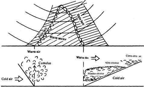
Cross section of fronts.
3.3.2. Weather
Fog is really a stratus cloud that forms at the ground or so close to it as too seriously imhair surface visibillity Cooling is the most frequent cause of fog formation. It may be due to loss of heat by the ground because of radiation (radiation or ground fog), loss of heat of warm air following over a coller surface (advection fog), adiabatic cooling of air streaming over rising terrain (up-slope fog). Fog may form as a result of nonsaturated air becoming saturated through evaporation from water warmer than the air-stream fog. If the evaporation is from rain falling through colder air, the fog is referred to as frontal fog.
Thunderstorms are generally classified according to the way the initial lifting action is accomplished. They are divided into two general groups, frontal thunderstorms and air-mass thunderstorms. Each thunderstorm progreses through a cycle which consists of the three stages: 1) the cumulus stage, 2) the mature stage, and 3) the dissipating stage or anvil stage. The hazards associated with thunderstorm clouds are: lifting, hail, altimeter errors, icing, snow, turbulence, rusts. One of the weather phenomena most respected by pilots is the squall line of thunderstorms which sometimes precedes a cold front.
Icing in caused by an accumulation of super-cooled water drops which form ice on air frames, engines, propellers, rotors, windows and other exposed surfaces of an aircraft and under certain conditions inside their power plants.
Three conditions are necessary for formation of either rime or glaze ice (not frost, however):
1) the presence of visible moisture
2) an outside air temperature at or below Freezing
3) an aircraft whose temperature is at freezing or less
There are several forms of ice which an aviator will encounter - snow, sleet, hail, propeller ice, rotor ice, windshield and canopy ice, Pitot tube ice and structural ice.
Turbulence is caused by random fluctuations of wind flow which arc instantaneous and irregular. There are four degrees of turbulence which the pilot should know: 1) light, 2) moderate, 3) severe, and 4) extreme, and four causes of turbulence 1) termal (or convective), 2) mechanical, 3) frontal, 4) large-scale wind shear. In addition to these phenomena, such as the wake turbulence.
Pilots operating at high altitudes should understand the following phenomena of high-altitude flight. Jet streams are very high-speed winds which usually flow west to east in narrow bands in the middle latitudes between 20000 - 40000 ft. Jet streams occur near regions where there is a large horizontal temperature difference between warm and cold air masses.
Clear air turbulence (CAT) is sometimes encountered in the vicinity of jet streams, probably as a result of large wind shears.
A contrail is generated in the wake of aircraft flying in clear cold humid air. There are three types: I) exhaust trails, 2) aerodynamic trails, 3) dissipation trails.
Canopy static is caused by solid particles (ice crystal of cirrus clouds) which brush against the canopy or other plexiglass-covered surfaces of the aircraft during flight and build up a static electric charge on them. When this static electricity is discharged, the accompanying noisy disturbance reduces radio reception.
There are ten principal sources of aviation weather information: 1) surface observation, 2) pilot balloon observation, 3) radar observation, 4) radiosonde observation, 5) weather recognizance flight, 6) meteoroligical rocket sounding, 7) satellite observation, 8) ships-at-sea report, 9) automatic meteorological observation stations (AMOS), 10) pilot reports.